Typhoon Haiyan (known in the Philippines as Typhoon Yolanda) is currently a powerful tropical cyclone crossing the central Philippines. Haiyan, which means petrel in Chinese is one of the most intense tropical cyclones on record.
On November 2, the Joint Typhoon Warning Center (JTWC) began monitoring a broad area of low pressure located about 425 km (265 mi) east-southeast of Pohnpei, a state of the Federated States of Micronesia. The system featured broken banding features alongside steadily consolidating convection.
Environmental conditions ahead of the disturbance favored tropical cyclogenesis and dynamic weather forecast models indicated the formation of a well-defined tropical cyclone within 72 hours.
Early on November 3, the Japan Meteorological Agency (JMA) classified the system as a tropical depression. Owing to a consolidating low-level circulation center with building deep convection, the JTWC also classified the system as a tropical depression, shortly after issuing a Tropical Cyclone Formation Alert.
Subsequent intensification resulted in the JMA upgrading the system to a tropical storm and assigning it the name Haiyan at 0000 UTC on November 4.
Meanwhile, the JTWC also upgraded it to a tropical storm, when the expansive system was steadily consolidating in an area of weak to moderate vertical wind shear and tracking westward along the southern periphery of a subtropical ridge.
By November 5, the storm began to undergo rapid intensification as a prominent central dense overcast with an embedded eye began developed. Owing to the formation of an eye, the JTWC estimated Haiyan to have achieved typhoon status around 0000 UTC that day. The JMA followed suit 18 hours later, by which time the JTWC estimated one-minute sustained winds to have reached 195 km/h (120 mph).
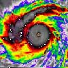
A small typhoon, with a core roughly 110 km (70 mi) across, rapid intensification continued through November 6 as a 11 km (7 mi) wide pin-hole eye formed. Upper-level outflow favored further strengthening of the system and was further enhanced by a Tropical Upper Tropospheric Trough to the northeast.
Intense banding features along the southern periphery of Haiyan wrapped into the system as well.
Early on November 6, the JTWC estimated the system to have achieved super typhoon status. That day, the Philippine Atmospheric, Geophysical and Astronomical Services Administration assigned the storm the local name Yolanda as it approached their area of responsibility. Intensification slowed somewhat during the day, though the JTWC estimated the storm to have attained Category 5-equivalent status on the Saffir–Simpson hurricane wind scale around 1200 UTC. At this time, Haiyan displayed a 15 km (9 mi) wide eye surrounded by a ring of deep convection. Later, the eye of the typhoon passed over the island of Kayangel in Palau.
Around 1200 UTC on November 7, Haiyan attained its peak intensity with ten-minute sustained winds of 235 km/h (145 mph) and a barometric pressure of 895 mbar (hPa; 26.43 inHg). Six hours later, the JTWC estimated Haiyan to have attained one-minute sustained winds of 315 km/h (195 mph). This unofficially ranked Haiyan as the fourth-strongest tropical cyclone on record, based solely on wind speeds.
The storm displayed some characteristics of an annular tropical cyclone, though a strong convective band remained present along the western side of the system. Satellite estimates at the time, using the Dvorak technique, reached the maximum level on the scale: T#8.0.
The storm’s structure exceeded the maximum intensity on the scale as, the “Dvorak technique makes no allowance for an eye embedded so deeply in cloud tops as cold as [cold dark gray],” as noted by the National Oceanic and Atmospheric Administration’s (NOAA) satellite analysis branch.
Some automated models initialized its intensity at T#8.1, exceeding the scale’s upper bounds. Through satellite estimates, NOAA also estimated that Haiyan achieved a minimum pressure between 858 mbar (hPa; 25.34 inHg) and 884 mbar (hPa; 26.11 inHg).
Nov 12, 2013
In the Philippines, President Benigno Aquino has declared a state of national calamity to speed relief efforts for victims of Typhoon Haiyan.
In a statement, he said the two worst affected provinces, Leyte and Samar, had suffered massive destruction and loss of life. Thousands of survivors are still desperately waiting for the aid effort to reach them. At least 10,000 people are feared to have been killed.
Tacloban is one of the worst affected cities. Hundreds of thousands more people have been displaced after the high winds and floodwaters destroyed their homes. Damage to roads and airports has delayed the delivery of aid.
Nov. 13, 2013
India is sending 15 tonnes of relief material to the Philippines. Addressing a press conference in Gurgaon yesterday at the conclusion of the two-day Asia-Europe Foreign Ministers’ meeting, External Affairs Minister Salman Khurshid said that an aircraft with 15 tonnes of relief supplies will depart for the Philippines.
President Pranab Mukherjee and Prime Minister Dr. Manomhan Singh have expressed grief and sorrow over the loss of life and destruction caused by the recent typhoon Haiyan in the Philippines, in which 10,000 people have reportedly died.
Meanwhile, the US Navy is sending a Japan-based aircraft carrier to the Philippines to step up relief efforts for the hundreds of thousands displaced by the Typhoon Haiyan.